Aktualizacja: 01.maja'2022


Blisko 61% powierzchni Grecji zajmują pasma górskie (śr. wysokość 1200-1800 m n.p.m.), które przyjmują przebieg południkowy. Obszary nizinne są niewielkie i występują w pobliżu wybrzeży (Nizina Salonicka, Tracka, Tesalska oraz Argolidzka). Półwysep Chalcydycki, tworzy 3 wtórne półwyspy: Athos, Longos i Kasandra.
Grecy mają ponad 3000 wysp. Z czego niewiele ponad 100 jest zamieszkałych. Trzy największe wyspy to Kreta, Evia i Lesvos. Odwiedzilismy na razie dwie z nich, ale wszystko przed nami :)
Kraj Fety i oliwek
Kraj uroczych, otwartych i pomocnych ludzi. Kraj, który jest, oczywiście jak na bałkańskie warunki, wyjątkowo czysty. I wyjątkowo bezpieczny. Naszym celem była "kolebka greckiej cywilizacji", a jak mówią sami mieszkańcy "kwintesencja greckości"- Peloponez. I wyśniony przeze mnie masyw Olimpu.


Teatry starogreckie
Unesco tentative list
 Teatry greckie na liście UNESCO
Starogrecki typ amfiteatru, służący wystawianiu sztuk widowiskowych. Składał się z widowni umieszczonej na stoku naturalnego wzniesienia i orchestry, z czasem schemat wzbogacono o proskenion (odpowiednik dzisiejszej sceny) i zaplecze dla aktorów (skene), a potem o kolejne elementy. Jako wzorzec dla budowli tego typu posłużył ateński teatr Dionizosa. Rozwój greckich budowli teatralnych można rozpatrywać w podziale na okres klasyczny, hellenistyczny i grecko-rzymski. Teatr grecki stał się wzorem dla budowanych w okresie późniejszym teatrów rzymskich..

Tesalia
Z notatnika krajoznawcy

źródło: Wikipedia
 Ancient Greek Theatre of Larissa
Ancient Greek Theatre of Delos
Ancient Greek Theatre of Melos
Ancient Greek Theatre of Lindos
Tesalia to w większości niziny (Nizina Tesalska), które otaczają masywy górskie takie jak: Olimp, Pindos, Othris, Ossa i Pelion.
Meteora (N III / K I, II, IV, V / 1988)
W regionie prawie niedostępnych, granitowych szczytów, pierwsi eremici zamieszkali na “podniebnych kolumnach" już w XI w. W XV w., w okresie odnowy ideału pustelniczego, za cenę ogromnego wysiłku zbudowano tam dwadzieścia cztery klasztory. Ich XVI- wieczne freski stanowią istotny etap w rozwoju malarstwa postbizantyjskiego.
>
więcej na whc.unesco.org [EN]
The broader region of Mount Olympus
Unesco tentative list
Olympus, the highest mountain in Greece (the highest peak is 2,918 m. above sea level), rises on the border of Macedonia and Thessaly, between the provinces of Pieria and Larissa. Owing to its specific microclimate, which is partly due to the short distance from the sea and the steep increase in height above sea level, it stands out for its great diversity in terrain, climate and vegetation.
The shape of the massif and the majestic peaks, covered in fog and low-hanging clouds, which often bring storms, in conjunction with its diverse and changeable natural beauty, have always induced awe and admiration. In this eerie landscape, the ancient Greeks placed the residence of the Twelve Gods of Olympus (with Zeus at their head), the Muses and the Graces. There, according to Hesiod, Zeus fought Cronus and the Titans and, after winning, settled there and became lord all the gods, demigods and humans. The myths and traditions collected by Homer and Hesiod were passed on throughout the ancient Greek and Roman world, making Olympus the epicentre of ancient Greek mythology and a symbol of Greek civilization.
According to ancient Greek tradition, the twelve gods lived in the gorges – or ‘folds of Olympus’ as Homer calls them – where their Pałaces were situated. On the highest peak was the throne of Zeus.
>
więcej na whc.unesco.org [EN]
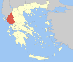
Epir
Epir to kraina górzysta, zajmująca obszar północno-zachodniej części Grecji, przy granicy z Albanią. Od zachodu oblewana jest przez wody Morza Jońskiego. Graniczy z Tesalią, Macedonią Zachodnią, Grecją Zachodnią, Grecją Środkową.

Zagorochoria – North Pindos National Park
Unesco tentative list
Zagori (“the place behind the mountains”, from the Slavic za “behind” and gora “mountain”) constitutes a distinctive geographic and cultural unit of great architectural and environmental interest. Its own inhabitants divide it, based on the natural boundaries traced by the local rivers, into four subunits: Vlachozagoro, Lakka Zagoriou (the villages in the Zagoritikos river valley), the Villages of the Ano Vikos Valley and the Villages of the Voidomatis Valley. These four subunits form a single territorial unit, Zagori. Its first settlements, its oldest core, lie in the west part of present-day Zagori (Papigo and Pedina). The two other parts developed later. Most of the modern villages were established during the Ottoman period, while most of the villages of East Zagori were founded in the 15th century.
>
więcej na whc.unesco.org [EN]
Archaeological site of Nikopolis
Unesco tentative list
The city, with the fortification walls and the cemeteries, occupies a fertile strip of land between the Ionian Sea to the west and the Ambracian Gulf to the east, where two of the three city harbours were located. The third harbour ran along both sides of the inlet known as Ormos Vathy at the north edge of the modern city of Preveza. The city occupies an area of approximately 375 acres. The plan of the city was the rectangular grid with the Decumanus (the main east-west street) and the Cardo (main north-south street) intersecting at its centre. Nikopolis was planned within walls with four main gates at the compass points. The southern quarters of the city were mainly composed of residential houses but also included the Odeion, while the northern section saw the construction of the Monument of Augustus, the Theatre, the Gymnasium and the Stadium. This area, known to ancient writers as the “Suburb”, is located outside the Roman fortification walls, on the hills, with a magnificent view of the Ionian sea and the Preveza peninsula. The city had a very effective water-supply system. An impressive 50-km-long aqueduct, consisting of a series of arches (arcade) and tunnels, carried water from the Louros springs to the Nymphaeum, from where it was distributed within the city.
>więcej na whc.unesco.org [EN]
źródło: Wikipedia
Ancient Greek Theatre of Delphi
Ancient Greek Theatre of Eretria
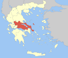
GRECJA Środkowa:
Obejmuje swoim obszarem krainę historyczną Grecja Środkowa z wyłączeniem jej zachodniej części. Do regionu przynależy również duża wyspa Eubea u jego wschodnich wybrzeży.
Region graniczy od południowego wschodu z regionem Attyka, od północy z regionem Tesalia, od zachodu z Grecją Zachodnią. Od południa ograniczony jest Zatoką Koryncką, od wschodu Morzem Egejskim.
Stolicą regionu jest Lamia.
Stanowisko archeologiczne w Delfach (K I, II, III, IV, VI / 1987)
Sanktuarium panhelleńskie w Delfach, gdzie przemawiała wyrocznia Apollina, mieściło Omfalós, “pępek świata". Przesiąknięte uświęconymi treściami, harmonijnie wtopione we wspaniały krajobraz, w V w. p.n.e. stanowiło prawdziwe centrum i symbol jedności Grecji.
>więcej na whc.unesco.org [EN]
Osios Loukas w Beocji (Fokida koło Delf)
[w:] Klasztory Dafni w Attyce, Osios Loukas w Beocji i Nea Moni na Chios (K I, IV / 1990)
Trzy oddalone od siebie geograficznie klasztory- pierwszy w Attyce, koło Aten, drugi w Fokidzie, w okolicach Delf, a trzeci na jednej z wysp Morza Egejskiego, w pobliżu Azji Mniejszej- należą do tej samej serii typologicznej i posiadają podobne cechy estetyczne. Zbudowane są na planie centralnym i przekryte wielką kopułą wspartą na narożnych trompach, umożliwiających przejście do planu ośmiobocznego. W XI i XII w. zostały ozdobione wspaniałą dekoracją z marmuru oraz pięknymi mozaikami na złotym tle, charakterystycznymi dla “drugiego renesansu bizantyjskiego".
>
więcej na whc.unesco.org [EN]
Wyspy z archipelagu:
SkirosSkopelosAlonisosSkiatos SamosIkaria
Sporady:
Dwa archipelagi na Morzu Egejskim, znanych pod nazwą Sporady Południowe i Sporady Północne. Sporady północne administracyjnie należą do Tesalii, zaś południowe do Dodekanezu.
Tutaj potraktujemy je w oderwaniu od lądu stałego, zaś południowe wrzucimy do Dodekanezu (ach to Rodos...)
Na Samos warto zobaczyć:
Tunel Eupalinosa - Muzeum oraz słynny podziemny akwedukt wybudowany w VI w. p.n.e. przez Eupalinosa.
Herajon na Samos - Ruiny wybudowanej w VIII wieku p.n.e. jońskiej świątyni, wzniesionej ku czci bogini Hery.
Jaskinia Pitagorasa
Copyright © MUWIT.pl
O portalu |
autorzy |