Aktualizacja: 01.maja'2022


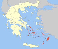
Dodekanez -
ie (gr. Δωδεκάνησα, Dodekánisa, co znaczy „dwanaście wysp”) – archipelag na Morzu Egejskim i do końca 2010 roku prefektura (nomos) w regionie administracyjnym Wyspy Egejskie Południowe w Grecji ze stolicą w Rodos. Prefektura Dodekanez zajmowała łączną powierzchnię 2714 km2, zamieszkiwało ją około 200,5 tys. ludzi (stan z roku 2005). Powierzchnia wysp jest przeważnie górzysta. Panuje tu klimat śródziemnomorski z łagodnymi zimami i upalnymi, suchymi latami.
Cyklady do końca 2010 roku były jedną z prefektur (nomosów) w regionie administracyjnym Wyspy Egejskie Południowe, ze stolicą w Ermupolis na wyspie Síros.
W skład archipelagu wchodzi około 220 wysp i wysepek o łącznej powierzchni 2572 km2. Archipelag Cyklady składa się z wieńca wysp o zróżnicowanym krajobrazie, rozsianych między skalistymi szczytami i błękitnymi wodami Morza Egejskiego. Archipelag słynie z tarasowych miasteczek, niekończących się plaż, weneckich zamków i wiatraków.

Delos (K II, III, IV, VI / 1990)
Delos, maleńka wyspa archipelagu Cyklad, była miejscem narodzin Apollina. Jego sanktuarium przyciągało pielgrzymów z całej Grecji, a miasto było kwitnącym portem handlowym. Wyspa Delos stanowi unikalne świadectwo cywilizacji basenu Morza Egejskiego, następujących po sobie od III tysiąclecia p.n.e. po czasy wczesnochrześcijańskie. Rozległe stanowisko archeologiczne daje obraz wielkiego, kosmopolitycznego portu Morza Śródziemnego.
>
więcej na whc.unesco.org [EN]

Ancient Towers of the Aegean Sea
Unesco tentative list
The numerous ancient towers scattered across many Aegean islands (Amorgos, Andros, Thasos, Ikaria, Kea, Kythnos, Mykonos, Naxos, Serifos, Sifnos, Skiathos, Paros, Tinos, etc.) and the mainland, constitute a particular type of ancient building with various uses. The vast majority of the towers are dated to around the mid-4th c. BC and up to the first quarter of the 3rd c. BC. Despite their numbers and dispersal, they present common architectural features, such as their circular, square or rectangular plan and their sturdy construction of local stone.
The towers were built in non-urban areas, in order to serve a wide range of needs depending on circumstances and location. The main motive for their construction was defence in the wider sense, i.e. the protection of people, animals and goods. The towers sometimes formed part of a wider system of defences and refuges, while others functioned as watchtowers and lighthouses. They are also often found in areas where mining activities are attested. One notable use of towers is as points in an early communication system consisting of networks of beacons (fryktoriai), for the transmission of light signals between towers in direct line of sight, in some cases covering extremely wide geographical areas. Sometimes the towers formed the main building of farmhouses owned by wealthy citizens. Towers of later date in the Cyclades, built to serve similar needs, are almost identical parallels to these.
A multitude of ancient towers, dominating the characteristic island landscape, are preserved in the Aegean. Many preserve their integrity to a striking degree, while a major project for their restoration and promotion has been undertaken in recent years.
Cheimarros Tower, Naxos |
Tower of Agios Petros, Andros |
Tower of Agia Triada, Arkesini, Amorgos |
White Tower, Siphnos |
White Tower, Serifos |
Tower of Agia Marina, Kea |
Tower of Kastellorizo, Rodos |
Tower of Ro, Rodos |
Tower of Strongyli, Rodos |
>więcej na whc.unesco.org [EN]
Średniowieczne miasto Rodos (K II, IV, V / 1988)
W latach 1309-1523 wyspę zajmowali joannici, którzy przekształcili ją w miasto warowne. Następnie wyspa przechodziła kolejno pod panowanie tureckie i włoskie. Górne Miasto, z Pałacem Wielkich Mistrzów, Szpitalem i Ulicą Kawalerów, stanowi jeden z najpiękniejszych gotyckich zespołów miejskich. W Dolnym Mieście znajdują się zarówno budowle gotyckie, jak i meczety, łaźnie publiczne oraz inne zabudowania z okresu ottomańskiego.
>więcej na whc.unesco.org [EN]
Fortyfikacje na Rodos (miasto Rodos)
[in:]
Late Medieval Bastioned Fortifications in Greece -
Unesco tentative list
With the appearance and establishment, in the 15th century, of the use of gunpowder, a new, powerful and destructive means of warfare, city fortification practices changed. Since medieval fortifications were unable to withstand the constantly increasing artillery power, additional defensive structures began to be added to existing fortresses. This change was completed in the 16th century, establishing the “bastion system” or “fronte bastionato”, based on the principle of “flanking fire”. In the 17th century, the need to confront even greater artillery firepower led to the construction of a multitude of smaller fortifications outside the main moat, whose aim was to keep the enemy as far away as possible from the main fortifications. Finally, up to the end of the 18th century, fortification architecture would continue to be based on the principles of the 16th century, while of course following the development of artillery. This development is documented by a series of fortifications on Greek territory.
These fortifications are mostly found in areas that passed into Latin hands, such as the Peloponnese, the coasts of Western Greece, the Ionian Islands, Crete and the Dodecanese. Most were built on the site of older, ancient and/or Byzantine fortifications, but their main phase was constructed during the various phases of Latin domination.
These are particularly well-preserved fortification works, which largely retain their integrity and original layout intact to the present day. This is very significant, given that they were built by the leading engineers of the time and closely follow developments in the field of defensive art. In recent years restoration projects for their protection and enhancement have taken place preserving however their particular character and their relation to the surrounding area.
The fortifications also contribute to the study of the urban areas of which they form a part, providing valuable information on the organisation of urban planning, which they determined in several cases.
The proposed fortifications are strategically positioned on the hubs of the trade routes between West and East and also North and South, and therefore played an important part as trading stations in the East Mediterranean basin.
>więcej na whc.unesco.org [EN]
>więcej na whc.unesco.org [EN]
Zabytkowe centrum (Chora) z klasztorem Św. Jana Teologa oraz Jaskinią Apokalipsy na wyspie Patmos (K III, IV, VI / 1999)
Wysepka Patmos w archipelagu Dodekanezu uznawana jest za miejsce, gdzie święty Jan Teolog napisał swą Ewangelię oraz Apokalipsę. W końcu X w. powstał tam klasztor poświęcony “ulubionemu uczniowi", który stał się odtąd miejscem pielgrzymek oraz nauczania greckiej religii prawosławnej. Ten wspaniały kompleks klasztorny góruje nad wyspą, a w przylegającym doń miasteczku Chora znajdują się liczne budowle sakralne i świeckie.
>więcej na whc.unesco.org [EN]
Copyright © MUWIT.pl
O portalu |
autorzy |